
Mapping project documents county’s numerous cemeteries
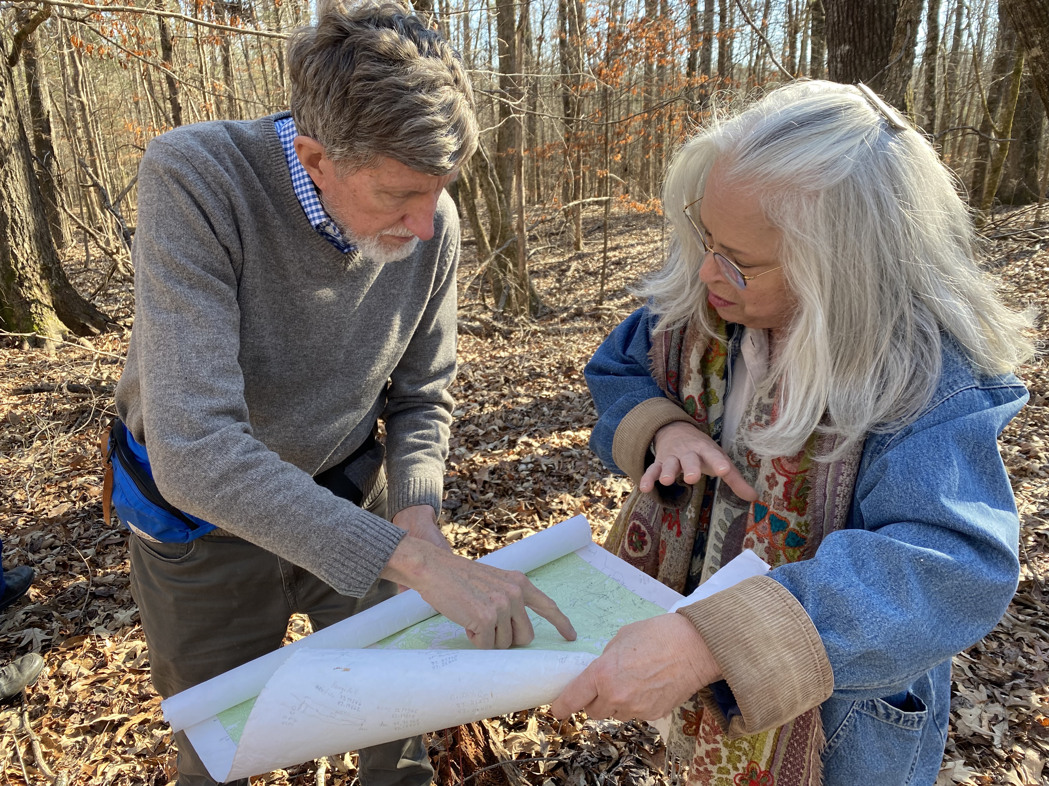
Stepping over branches in a wooded area near Crawford, Tom Gresham had no doubt he was looking at a cemetery. As an archeologist, he sees what others may miss — rocks become grave-markers, facing east. A slumping patch of earth becomes the sunken ground where a person was buried. Berms, hilltops and hardwood trees transform from just part of the landscape into hard-to-miss markers of historic cemeteries.
“Oh, see that’s clear as a bell,” Gresham said, leaves crunching underfoot. “See what I’m talking about — the linear depression — and graves almost always are buried east (to) west, head to the west, looking east for the Second Coming,” he explained, gesturing toward a grave.
Gresham will add the cemetery, which is on Church Crow’s property, to a list of nearly 460 cemeteries in Oglethorpe County, which he has been mapping since the 1990s. Gresham has worked with other members of Historic Oglethorpe County to meticulously record each cemetery’s location in books, and later on the county tax assessor’s website.
By tracking the locations of these cemeteries, the historical society ensures they aren’t forgotten.
Gresham became one of the leaders of the mapping project in its beginnings. Volunteers divided the county into sections and began recording the information from the tombstones — names, family member’s names, birth and death dates. By 1995, the group had enough information to publish a book, “Cemeteries of Oglethorpe County, Georgia.” Even with the book completed, they didn’t have plans to stop.
“Sure enough, as soon as we got the book published, we started learning, ‘Oh, there’s another one,’ and ‘Oh, you made a mistake over here,’” Gresham said. “So we immediately started recording the new cemeteries, the ones that weren’t in our book.”
The book is in its sixth edition.
“(Gresham) has the best cemetery book in the state of Georgia, and that’s no (exaggeration),” said Athens native Gary Doster, who collects historical memorabilia and volunteers in the cemetery project.
While one of the initial reasons for mapping the cemeteries was to preserve information for historians and genealogists, there was another reason that inspired Historic Oglethorpe County to map cemeteries: to ensure they aren’t lost to time.
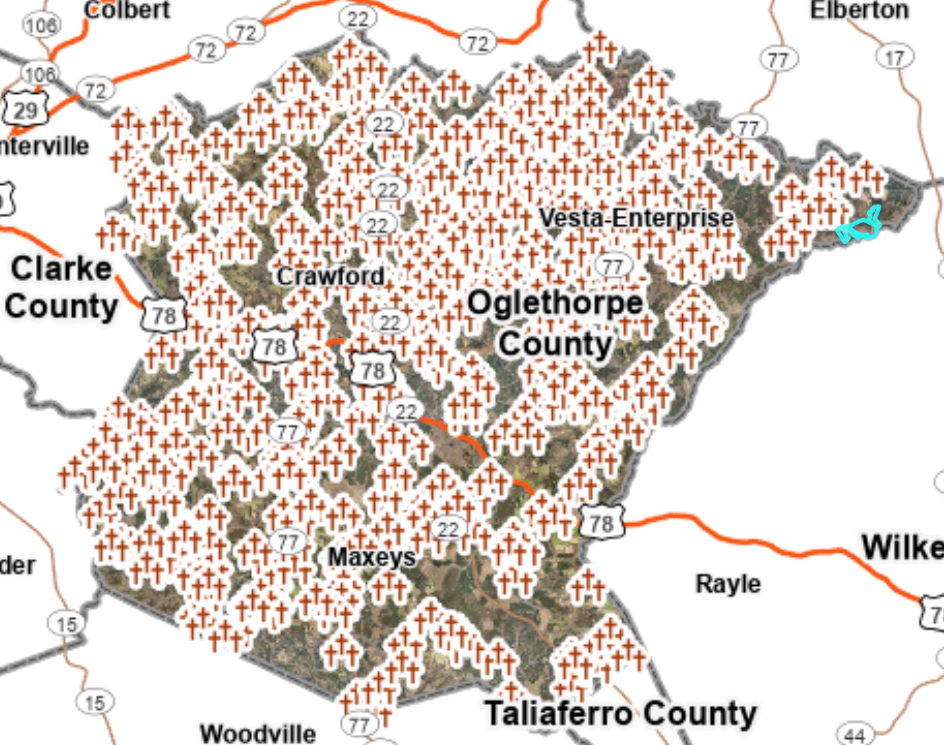
Cemeteries without tombstones are easy to miss. For this reason, many historic rural cemeteries have been developed or lost altogether. Because Oglethorpe County’s cemeteries are included on the online tax assessor’s map, property owners and officials have cemetery coordinates at their fingertips.
“If somebody wants to build a set of three new chicken houses, the county planning and zoning commission will look at their online map and see if there’s any cemeteries there,” Gresham said.
Preserving history
While the tax assessor’s map will prevent documented cemeteries from being lost, there are still cemeteries being documented in Oglethorpe County. The cemetery Gresham recently documented on Crow’s property is one example.
Crow is a member of the Barrow family, and her property has been in the family for generations. Behind her house, there’s an elaborate walled cemetery where some of her ancestors are buried. The more recently uncovered cemetery is in the woods further from the house.
Based on oral history, Crow and her sister believe this may be where their family buried slaves.
“If this property had not stayed in the hands of the same family for 200 years, and if it hadn't gone through a period when nobody was living here or doing anything with it, if it changed hands, we could have lost that easily,” said Ruth Bracewell, Crow’s sister.
While many of the county’s historic cemeteries are on private property like Crow’s, the cemetery mapping project helps ensure county history isn’t lost, even as county development increases.
“That’s one of the main reasons we did this,” Gresham said. “(Cemeteries) aren’t going to get lost.”